Thursday, December 15, 2011

Final GIS project


This map shows areas in which new hospitals could be built in Los Angeles county. I used various criteria to create this map. The criteria that is pertinent to this class was that the new hospital location had to be within 5 miles of a magnitude 5 quake that has occurred since 1812.

Monday, December 12, 2011

Landsat satellites used to track Yellowstone's geothermal activity

Geothermal energy is threatening Yellowstone National Park's geothermal features. There are over 10,000 hot springs, geysers, and fumaroles in the park. Drilling directly outside of the park could cause some of these features to cease to exist. To help study and monitor the parks features is Landsat data. The Landsat data is using both visible and heat sensitive portions of the electromagnetic spectrum. Using this remote sensing technique, the monitoring will be using airborne reconnaissance circling the planet at over 400 miles above the surface. This new monitoring technique will be monitoring the heat given off by the thermal features. This data will provide scientists with an in depth look of the parks features and will cover a larger portion of the park than could just ground based monitoring forms. The data that has been collected so far has prompted scientists to launch a new Landsat satellite in early 2013 which will hopefully provide an even more in depth look at the parks features, including vegetation in addition to the thermal features. This technology is part of the developmental paradigm and will hopefully be proven to be a great monitoring tool and possibly great mitigation tool if there ever were to be an eruption from Yellowstone in the near future.
Satellite image on left, thermal image on right of the park.
http://www.sciencedaily.com/releases/2011/12/111207175738.htm

Sunday, December 11, 2011

California winds

Over the past week southern California has been experiencing winds of over 70 mph which is almost tropical storm strength. These winds are common this time of year in the state and are called the Santa Anna winds. Power outages have been common with over 300,000 people without power. Additionally, the winds have knocked over trees, caused small fires and  The region affected were the counties of Los Angeles, Orange, Riverside and San Bernardino. These counties include the greater Los Angeles area. The areas with the highest winds were in the valleys between the San Beranadino Mountains and along the coast. Unfortunately, these winds are hard to predict sometimes so mitigation becomes harder for the Santa Anna winds. The pattern for these winds are very sporadic and infrequent.

PHOTO: The National Weather Service issued high wind warnings and wind advisories for parts of California, Utah, Nevada, Arizona, New Mexico and Wyoming.
Tree on top of a home in Southern California
http://abcnews.go.com/US/fierce-santa-ana-winds-hit-southern-california/story?id=15065048

Thursday, December 8, 2011

Dust storms causing lung disease

    Large dust storms in Asia have been causing lung issues with the people of that region. High amounts of small particles around 2.5 micrometers have been found to have caused chronic lung disease in the populace. This was deduced by a Chinese scientist who analyzed data from hospital admissions. What he found was that the majority of admissions were respiratory related. Additionally the admissions generally took place just a few days after a large dust storm event. This research that is being done will hopefully result in the creation advanced warnings of potentially health-damaging effects. These warning systems will consist of national air quality indices and proactive alert services. This story relates to the behavioral paradigm and the developmental paradigm. By analyzing the behavior of people reacting to these dust storms has allowed for there to be more research into this hazard.


The cause of all of the dust storms
http://www.examiner.com/images/blog/EXID38571/images/asian_dust_storm-accu.jpg
http://www.sciencedaily.com/releases/2011/12/111205170053.htm

Monday, December 5, 2011

New drought maps created for Texas

The record drought in Texas, the worst drought in more than 60 years is now shown by maps made by NASA. These maps which were created on November 29, 2011 show groundwater and the low groundwater is clearly visible over east Texas. Experts believe that even if the state receives lots of winter rains/snow the severely depressed aquifers will still need much more time to fully recharge. Two satellites, NASA's Gravity Recovery and Climate Experiment (GRACE) are responsible for collecting the data for the maps. These satellites detect small changes in the planets gravity field, which is caused by the distribution of water. These maps will offer the general public a view that can only be obtained from satellites. The data collected by these satellites will also help water recourse managers and farmers allocate water accordingly, and will also allow the USGS to begin ground based surveys of the region. These maps are a part of both developmental and behavioral paradigms.


http://www.sciencedaily.com/releases/2011/11/111130171100.htm

Wednesday, November 30, 2011

Tornado radar dish used to measure snow?

University of Utah meteorologists are using radar dishes mounted on vehicles to measure snow and rainfall in depth. The study area is in the Wasatch mountains near Salt Lake City. The dish is an X-band polametric dish that measures wind speeds in excess of 300mph. The dish broadcasts waves both vertically and horizontally, which is more powerful than the national weather services dishes. The dish can measure the size of raindrops and snowflakes in great detail and collect data in hard to reach areas. So far the truck mounted radar has measured 10 different winter storms as of October. This would be a part of the developmental paradigm, and I am very excited to see the future of this technology.


Radar image of lake effect snow from The Great Salt Lake

http://www.sciencedaily.com/releases/2011/11/111110094846.htm

Sunday, November 27, 2011

Ozone from cracks in earth could help forecast quakes

Scientists have been trying to figure out easier, more efficient methods to forecast earthquakes for over 50 years. They might have found a new tool for their arsenal. The natural gas, ozone, which is a byproduct of electrical discharges into the air. Normally, ozone is discharged from lightning, however, now new findings show that ozone can be released from rocks breaking under immense pressures. Scientists have been drilling into different types of rocks and have discovered that different types of rocks produce different amounts of ozone. They have realized that rocks that have been under pressure prior to an earthquake will build up ozone from the high amounts of stress being put on them. Bedrock such as granite, basalt, and rhyolite were tested and produced some of the highest amounts of ozone gas. This latest discovery has scientists very excited, if rocks along faults under pressure produce amounts of ozone that are detectable, there is a high chance of much more accurate earthquake forecasting/predictions.


http://www.wired.com/images_blogs/wiredscience/2011/11/earthquake-cracks-road-flickr-martinluff.jpg

Article:http://www.sciencedaily.com/releases/2011/11/111117154635.htm

Saturday, November 19, 2011

California Earthquake Hazard Map

This is a map I created on Adobe Illustrator showing Earthquakes over magnitude 5 vs. the population of California.

Copyright: Matt Drahnak November 19, 2011

Monday, November 14, 2011

Large winter storm slams America's largest state

The largest storm in forty years has hit the state of Alaska. Hurricane force winds of around 137 mph pummeled Alaska's western coast creating massive sea surges. With this storm came heavy snow and rain which affected the entire western portion of the state. Over 40 communities have reported large amounts of damage from this storm with winds, flooding and erosion being the culprits of the damage caused. Other communities that were hit hard by this storm included the northwest Alaska villages of Point Hope, built on a large gravel spit, and Kivalina which is affected by landslides due to its highly eroded topography. The amount of people impacted in these two towns is around 1500 people. The location of where these towns were built had a direct relationship to the amount of damage that was endured by these towns. The large storm surges and flooding have resulted in mass wastage events to occur washing away homes.


Children play in sea foam near the Nome harbour as the big Bering Sea storm starts kicking up in Alaska this week.
http://www.cbc.ca/news/world/story/2011/11/10/alaska-storm-british-columbia.html?cmp=googleeditorspick

http://www.businessweek.com/ap/financialnews/D9QU9ROO0.htm

Sunday, November 6, 2011

Mudslide ravages Columbia

22 people are dead and 70 people are missing after heavy rain caused a landslide in the city of Manizales, Columbia. The landslide has destroyed at least 17 homes and is threatening to cause more evacuations on the region due to the persistent heavy rains. The La Nina season has been causing hundreds of thousands of evacuations in the country due to the persistent rains that have been pounding the region. Rescue workers with the Red Cross have begun searching for the missing people in the muddy debris. Since this region is high in coffee production, the high agriculture demand for the production of this high valued commodity has caused for there to be large areas of deforestation. These deforested areas are much more susceptible for mass movements (landslides to occur).


http://photoblog.msnbc.msn.com/_news/2011/11/05/8659135-mudslide-kills-four-and-leaves-28-missing-in-colombia

source: http://www.bbc.co.uk/news/world-latin-america-15613951

Thursday, November 3, 2011

New hyperspectral camera will be able to detect environmental hazards

 Tel Aviv University has just created a hyper spectral  camera that can analyse more than 300 times more information than the human brain. The human eye can only see the color spectrum whereas this camera can see thousands of colors which are invisible to humans eyes. The creators in Israel hope that this high resolution camera will provide real-time monitoring of forests (fires), urban areas (human health), agricultural lands (nitrogen runoff or erosion), and water bodies (oil spills). The camera has a very large view; it can see objects from up to 500 miles away which means that the device can be placed almost anywhere.

The creators in Israel hope that this camera will be able to detect pollution and other contaminates before they become hazardous to the environment. This story can be related to the Engineering paradigm because it clearly shows human beings creating technology to better understand our environmental impact on the planet and try to prevent future environmental catastrophes.

Tel Aviv
Article:  http://www.theengineer.co.uk/sectors/energy-and-environment/news/hyperspectral-camera-can-identify-environmental-hazards/1010789.article#ixzz1cf7TR9SB

Monday, October 31, 2011

Heavy snow in northeast puts a damper on Halloween weekend

Record snowfall totals are being set up and down the northeast this past Halloween weekend. Plainfield, Massachusetts saw 27 inches of wet snow in the past 48 hours which is a record for this time of year. Even New York City saw the flakes flying and they received around 1.5 inches. The heavy wet snow has caused 21 deaths in the region. These deaths have been associated with down electric wires,fallen trees from the wet snow and traffic accidents. Additionally this storm has also left three million without electricity. States of emergency have been declared in New Jersey, Connecticut, Massachusetts and certain parts of New York. Airports have been bogged down and some roads have become inaccessible for the time being. A lot of people were unprepared for the winter weather to strike so early in the season and therefore long term power outages and expected to occur for the remainder of today and into the rest of the week.

Looking at this situation from a complexity approach, the overall preparedness for this storm was low due to the fact that the entire northeast is still recovering from the Irene which flooded large areas of the region a few months ago wiping entire towns off the map in states such as Vermont. From a personal point of view however, after having worked in the northeast in New Hampshire I know that the people of this region are very hearty and they can deal with large snowstorms such as the Halloween blizzard.

image: http://www.sfgate.com/cgi-bin/article.cgi?f=/c/a/2011/10/30/MNFA1LOALE.DTL

Article: http://online.wsj.com/article/AP4a3385d8d10049a6825f80f1d086fed9.html

Wednesday, October 26, 2011

Mexico braces itself for yet another hurricane

Today a category 2 hurricane named Rina is expected to hit the eastern Mexican coast. The Mexican government has issued a hurricane warning for the east coast of the Yucatan Peninsula, which includes Cancun. NASA's Terra satellite passed over the large storm and took pictures. Then, NASA's Aqua satellite took measurements of the clouds using an infrared instrument mounted on the satellite. The infrared imagery showed powerful convection surrounding the eye of the hurricane. The fastest recorded winds of this storm now are around 110 mph. The infrared imagery also showed forecasts of rainfall estimates which range from 8-16 inches associated with this hurricane. Additionally the infrared data also showed that Rina is in an area of  warm ocean temperatures, which will allow the storm to potentially strengthen over time.

The satellite (remote sensing) technology is astounding and helps forecast hurricane strength,rainfall estimates,temperatures, and where storms could make landfall. Technology such as the satellite mounted intruments is the future for forecasting hurricanes and other dangerous storms as technology progresses foreward in this field of remote sensing.

Image taken by the Terra satellite.
 

Sunday, October 23, 2011

Devastating earthquake hits eastern Turkey

Earlier this morning a 7.2 magnitude earthquake hit the Lake Van region of eastern Turkey. The death toll stands at 138, with the majority of the deaths occuring in Van. In addition to the deaths there are at least 350 injured in the wake of the quake. Experts say this quake is the most powerful in more than a decade. Almost 100 buildings were destroyed in the quake including many homes/buildings around the lake. Additionally a student dormitory was destroyed resulting in many injuries. Rescue teams have already been deployed to dig through the rubble in search of survivors. A crisis center has been created in the country's capital Ankara. Concerns in the aftermath of the quake are the drastic search for survivors and possible flooding due to the displacement of Lake Van. Turkey has a fairly good response time for earthquakes. The structural integrity of some of the buildings in the rural areas of the country was one of the causes to the loss of life from this quake. Had the quake struck earlier in the day there could have been more injuries as people could have been sleeping in the homes that collapsed.

Turkey earthquake graphic
Location of the earthquake.
http://www.guardian.co.uk/world/2011/oct/23/turkey-earthquake-up-to-1000-feared-dead
http://www.cnn.com/2011/10/23/world/europe/turkey-earthquake/?hpt=wo_c2

Wednesday, October 19, 2011

Mass flooding in thailand

Thailand is being affected by floods and experts say that it is some of the worst flooding in decades. The entire country has been engulfed by the flood waters destroying roads,buildings and has killed almost 800 people so far.  The Thailand government has estimated the damage costs to be around 3 billion US dollars. The economic impact of these floods is that the global economy could potentially be slowed down. Thailand is a major source of economic supplies for the United states and the rest of the world due to the fact that there are many major factories/plants that produce electronics (Dell) and cars such as Toyota parts. This situation can be looked at with the social perspective because US consumers rely on this country to produce electronics for phones and cars and if the plants that produce these parts are slowed down, then so will the economy.

THAIFLOOD
Article and image:
http://www.businessweek.com/news/2011-10-18/western-digital-exports-from-thailand-to-fall-on-flood.html
http://online.wsj.com/article/SB10001424052970204618704576640883035602852.html

Sunday, October 16, 2011

Volcanic eruption causes chaos in Spain

Yesterday, volcanic debris (pyroclasts) were being thrown into the air caused the evacuation of more than 600 residents of the island of El Hierro. The island is part of the Canary Island hot spot chain and is very popular with European tourists. The activity has caused the busy port on La Restinga island to close and now ships and air crafts are banned form the area until the volcanic activity subsides. Currently the oceanic eruption is in deep enough waters here it shouldn't directly threaten the towns on the island. However, if the activity moves into shallower waters, there could be potential explosions from the hot volcanic material reacting with the water. 
MODIS image of El Hierro on the afternoon of Friday 14 October 2011

Location of the volcano in the Canary Island volcanic chain taken from the MODIS satellite
http://www.irishweatheronline.com/news/earth-science/geology/evidence-of-el-hierro-volcanic-eruption-visible-from-space/41796.html/comment-page-1

Article:
http://www.volcanodiscovery.com/view_news/2421/El-Hierro-volcano-Canary-Islands-Spain-eruption-update.html

Tuesday, October 11, 2011

Category 3 hurricane to hit Mexico later today

Hurricane Jova is expected to make landfall on the Pacific coast of Mexico today. The storm is now a category 3, just becoming a category 3 on Monday with winds of excess of 115 mph. The storm is one of the largest in almost a decade and is threatening resort towns along the coast. Puerto Vallarta is directly in the hurricanes path and is expecting flooding, heavy rains, and large waves. The rains and waves are expected to have the greatest impact due to the fact that the population is on the coast. Additionally, logging (deforestation in the region) has weakened the slopes in the mountainous portions of the affected region and landslides are now a possibility too. These ever growing threats associated with the storm have caused for hurricane warnings to be issued by the Mexican government.
This October 9, 2011 handout image courtesy of
Satellite image of Hurricane Jova
http://www.newsday.com/news/weather/hurricane-jova-becomes-a-major-storm-in-pacific-1.3234113

Image Detail

Forecast predictions for Mexican coast
http://www.cruisecritic.com/news/news.cfm?ID=4623

Article
http://www.businessweek.com/news/2011-10-11/hurricane-jova-heads-for-mexico-coast-as-warnings-issued.html

Monday, October 10, 2011

Oil spill- New Zealand

An oil spill has occurred on the eastern coast of New Zealand near Tauranga late yesterday. So far around 50 tons of hazardous oil has been leaked into the ocean and now there are reports of oil washing up on the New Zealand beaches. The government of new Zealand are urging tourists on the beaches to not go near the oil due to health hazards and its high flammability. The oil spill is now threatening the diverse wildlife in the region which includes penguins, seals and various birds. Additionally the impacted area s located in wildlife migration routes which could pose problems to dolphins and whales migrating for the wintertime. The cargo ship that spilled the oil was called the Rena, after it ran across a reef rupturing the tanker. The total amount of fuel in the ship was 1700 tons of oil. Efforts are slow to start the cleanup of the oil and the WWF are worried that these slow efforts will only worsen the situation for wildlife in the region.

Article:
http://www.guardian.co.uk/environment/2011/oct/10/new-zealand-oil-spill-wildlife-tragedy?newsfeed=true


An oil covered penguin off the coast of NZ
http://www.voxy.co.nz/files/imagecache/news_item_image/files/blue-penguin_1.jpg

Tuesday, October 4, 2011

Lab 4 entry: Yellowstone Wildfires of 1988

The great wildfires of the 1988 summer in Yellowstone will always be ingrained into the memories of the residents who live in the area. The fires started in mid July and lasted until September 11,1988 when rain/snow fell in the area. During those long three months, 63 percent of the park burned and around 300 mammals in the park were killed. How these horrific fires started was mainly from lightning strikes (42) but there was also a human factor as well. Nine of the 51 fires were started by human carelessness (cigarette butts, improper extunguished fires). All of this could have been prevented had the natural burn policy not been implemented that year. The federal government in total spent 120 million dollars fighting the fires and around 25,000 people were on the ground or flying above fighting the inferno. The firefighters saved people's property but the environmental damage was much higher due to the extreme drought that was occurring that summer.

The Crown fire of 1988 in Yellowstone National Park (affected mammals shown in foreground)
http://www.thefurtrapper.com/images/Crown%20Fire%20Elk.jpg

From a complexity approach there could have been outside factors that could have made the fires much worse. More people would have been affected by these fires had Wyoming's low amount of private homes built in wilderness areas near the park expanded. Had there been a higher population density around the park many more homes/lives would have been affected that summer and the price tag (cost) of the fires would have been higher. Additionally, had there been a higher density of dead plant matter on the forest floor (fuel) the fires would have destroyed even more acreage of the park instead of just 63 percent. Fire suppression had led to the loss of diverse plant species and has also led to a larger fire risk in these areas where suppression of fires is the norm.

Steep slopes (topography) of the land in the region also allowed for the quick spread and the intensity of the fires as well. Rain also would have played a large factor into mitigating the fires as well. The summer of 1988 was one of the driest seasons on record only receiving 8.5 inches of rain total. Had there been even less rain maybe around 3 inches instead the fires would have started even sooner than they did. On the opposite side of the spectrum had there been more rain not nearly as many fires would have started that year and they possibly could have been contained quicker. Wind also intensifies fire behavior and had the winds been gusting stronger on certain days, the fire could have spread out much quicker. The other risks associated with the Yellowstone fires are in conjunction with the density of the road system in the park, the density of lightning strikes that occur in the park and historic fire locations.

What everyone has learned from this event is to educate the public about the dangers and causes of forest fires. New mitigation strategies have been created from this event to help further prevent an outbreak like the fires of 1988 from occurring again (see links page).

 
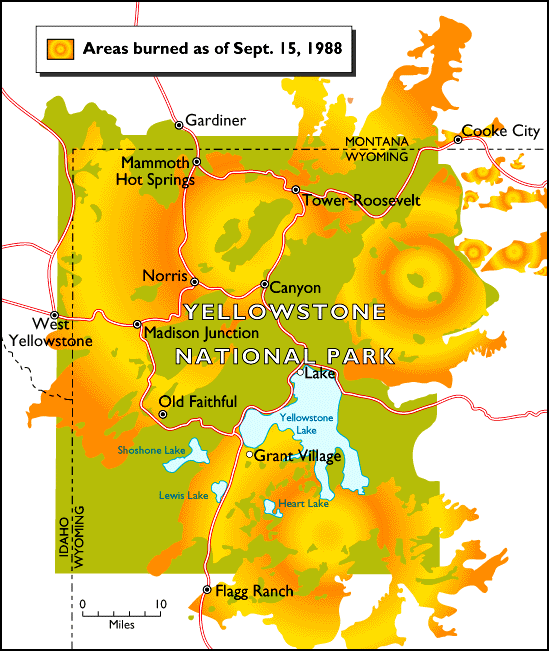
Extent of burned area due to the 1988 wildfires in Yellowstone
http://wildfiretoday.com/2009/08/20/yellowstone-fires-big-blowup-august-20-1988/


Links: http://www.firewisewyoming.com/firebehavior1.html
http://wyohomelandsecurity.state.wy.us/Library/mitigation_plan/Chap17_Wildland_Fire.pdf

Monday, October 3, 2011

Effects of Fukushima plant being felt still

  Large quantities of Plutonium has been leaked into the Japanese countryside from the Fukushima nuclear plant. The tsunami affected plant which was crippled in March has been leaking the harmful radioactive substance into the soil. The substance has been found 40km away from the plant in at least six different places surrounding the plant.

  The vast breadth of the affected area is prompting evacuation orders although none have been issued as of yet. Scientists warn that the long half life of plutonium (up to 24,0000 years) could have long term health hazards on the Japanese populace such as lung cancers and leukemia. Additionally, the Japanese government is in fierce debate about the the severity of the plutonium and whether or not an evacuation is necessary at this point in time.


Locations that Plutonium has been discovered
Image source: http://www.yomiuri.co.jp/dy/national/T111001002464.htm


Articles: http://www.ft.com/cms/s/0/7e3af460-ece6-11e0-be97-00144feab49a.html#axzz1ZjjjQacc
 http://online.wsj.com/article/SB10001424052970204226204576604013365441594.html

Sunday, October 2, 2011

Tornado hits South Africa

Most people would think that tornadoes are rare in South Africa, however this is not the case. Earlier on Sunday a powerful tornado hit the town of Ficksburg which is located very close to the small country of Lesotho in the Maluti Mountains. Thousands of homes were demolished in the outbreak and at least one young boy was killed. Additionally, more than 40 other people have b een taken to nearby hospitals for wounds. Search and rescue efforts are underway, and the death tool so far doesnt look like it will be too high.


Monthly tornado average for South Africa.

Image: http://3.bp.blogspot.com/
_a1AVUIK5Er8/Sv0fQREuZwI/AAAAAAAAGLw/
poCowQnNmVg/s400/TORNADO+GRAPH.jpg


Article: http://www.irishweatheronline.com/news/atmosphere/storm/tornado-kills-boy-9-destroys-over-1000-homes-in-ficksburg-south-africa/40432.html

Monday, September 26, 2011

Monsoon rains causing distress in India

Monsoon season is here: more than 2 million people have been affected by the current monsoonal moisture pummeling the country of India. Almost 80 people have been killed by the tremendous flood waters from heavy monsoon rains. The rain isn't going to let up anytime soon either; forecasts are expecting the rain to still last at least a few more days. The flood waters have forced residents of the affected cities to the trees to escape the fast moving waters. Since the monsoon rains began in August many homes have been completely washed away with its residents still inside, most of the deaths occurring at night. One of the hardest hit areas in India by the  heavy rain is the state Orissa in eastern India, which is where the majority of the deaths have occured so far.


Image:http://news.bbc.co.uk/olmedia/1445000/images/_1448701_india_orissa_flood2_150.gif


Article:http://www.bbc.co.uk/news/world-south-asia-15056411

Sunday, September 25, 2011

Famine in Somalia creating violence

The horrific, unspeakable famine that has been plaguing Somalia is taking a turn for the worst. Over 750,000 Somalians are foreseen to be affected by this current famine that has struck the East African country. Nearly half of this number is under the age of five years old. These affected people are being taken advantage of by something much worse than famine itself. As Somalians head to the boarder of Somalia/Kenya for refuge, they are met by violent bandits who want nothing more than to rape, kill and steal. Adding to the current crisis is the high birth rate in the country which directly affects the demand for food in the country.

Dadaab the third largest city in Kenya is now a massive refugee camp for the fleeing Somalians and is still growing at an rapid rate each day. This famine in East Africa is overlooked by the American media and isn't getting enough coverage which is quite upsetting. However despite the poor media coverage, the UN has banded together and up to 60 countries now have donated money for relief in both Kenya and Somalia.


UN declared famine area
Image source: http://www.npr.org/news/graphics/locator-maps/map-somalia-famine-300.gif


Areas of the country where famine has struck
Image source: http://blogs.nature.com/houseofwisdom/images/Famine%20Somalia.png


Article Sources: http://www.nytimes.com/2011/09/25/opinion/sunday/kristof-on-top-of-famine-unspeakable-violence.html

http://www.soschildrensvillages.ca/News/News/child-charity-news/Pages/New-Funds-Pledged-Horn-Africa-709.aspx

Tuesday, September 20, 2011

Large typhoon hits the already devastated Japan

Typhoon Roke has forced over 1.3 million Japanese inhabitants to leave their homes today as the storm hones in on the mainland of the country. The large city of Nagoya is directly in the path of the Typhoon which is composed of the majority of the people affected by this storm. Officials from the city of Nagoya are asking for military aid to help out the affected populace.The winds of Roke are around 140 km per hour and the storm is threatening the mainland with landslides, heavy rain and flooding due to rivers reaching flood stage.

The region is still trying to recover from another recent tropical storm that hit the islands which left 100 dead in its wake. Luckily, the islands have ample enough warning for these kind of events and should be able to prevent major devastation from occurring from this storm. Additionally, the nuclear power plant that was affected by the March earthquake/tsunami is not in the typhoon's path, which brings a sigh of relief to the Japanese people.


Image source:
http://www.thirdage.com/files/originals/typhoon_0.jpg


Article source: http://www.abc.net.au/news/2011-09-20/japan-evacuates-as-typhoon-looms/2908552

Sunday, September 18, 2011

Large earthquake hits India

This morning Sunday September 18th, 2011 at 8:40 AM Eastern Time, a 6.9 magnitude earthquake occurred at depth of 12.2 miles. The quake hit the northern Indian state of Sikkim, which borders Nepal. The area hit by the earthquake is in the mountainous Himalayas range. The quake was so powerful that it sent members of the Indian Parliament running out of their assembly hall.

Luckily there was no tsunamis warnings issued for the area. However, there have been casualties already; the death toll is at 63 and many more have been injured. At least 100,000 homes were wiped out as well. Collapsed buildings,cracked sidewalks, landslides, and power outages were also associated with this quake closest to the epicenter of the quake near the city of Gangtok. Emergency response crews are rapidly responding to the quake and rescues are underway. At least 6,000 troops are scrambling to clean up debris from destroyed buildings.

Earthquake Location


Image source:
http://earthquake.usgs.gov/earthquakes/recenteqsww/Quakes/usc0005wg6.php


Articles used: http://www.usatoday.com/news/world/story/2011-09-18/india-earthquake-fatalities/50456078/1

http://www.guardian.co.uk/world/2011/sep/19/himalayan-earthquake-kills-dozens

Wednesday, September 14, 2011

Smoke from forest fires blanket WI, IL

A forest fire in the Pagami Creek Region in the Boundary Waters Canoe Area Wilderness near Ely, MN has been causing hazy conditions and health hazards today. The hardest hit areas were in Wisconsin and Illinois. Smoke from the nearly 100,000 acre forest fire has traveled nearly 600 miles to Eastern Wisconsin near Milwaukee and portions of Chicago. Health officials are worried that inhaling the smoke could cause upper respiratory and allergy concerns for children and older residents of those areas.

The fire started August 18, 2011 when lighting struck 20 miles away from Ely due to the dry conditions the flames began spreading quickly this week after the dry, cold front passed through on Monday bringing with it high winds thus fanning the flames. Hundreds of firefighters were expected to arrive in northern Minnesota today to help combat the fire today, and the cooler temperatures should also help calm the fire's intensity.

  
Aerial image showing the smoke plume traveling across Lake Superior into WI.
Source for image: www.crh.noaa.gov/news/display_cmsstory.php?wfo=mkx&storyid=72984&source=0

Article source: http://heraldnews.suntimes.com/news/7639146-418/haze-from-minnesota-wildfire-prompts-health-warning.html

Sunday, September 11, 2011

Texas wildfires worst in state's history

Texas firefighters have been kept on their toes this entire wildfire season. Since the wildfire season began in Texas in December the state has experienced more than 20,900 wildfires that have consumed about 3.6 million acres which is roughly the size of Connecticut. The worst of the fires in the state is the Bastrop fire located in central Texas. This fire has destroyed 1400 homes in the area, killed four people and has caused thousands of people to vacate the area.

The current status of the Bastrop fire is about 40 percent contained, and the weather forecast doesn't show much relief for the area. The drought situation in Texas is listed as extreme and all of the counties in Texas have banned outdoor fires for the remainder of the drought.


Source for image:http://droughtmonitor.unl.edu/DM_state.htm?TX,S


Articles cited:
http://www.reuters.com/article/2011/09/10/us-wildfires-texas-idUSTRE7892SR20110910

http://www.firerescue1.com/urban-interface/articles/1121740-String-of-fires-takes-toll-on-Texas-firefighters/

Thursday, September 8, 2011

Hurricane Season in full swing!

The last few weeks have certainly been active with hurricanes. A normal hurricane season begins mid August and continues into the first two weeks of September, normally peaking on September 9th or 10th, a day away from now. The season started off booming with Hurricane Irene hitting the east coast on August 24, 2011 affecting over 55 million people. Irene caused significant flooding in many of the northeastern states with Vermont being one of the states most hard hit. The floods in the northeast destroyed covered bridges in Vermont, washed out roads in Vermont and New Hampshire, and killed 44 people in at least 5 different states.

To make matters worse, about one week later there was Tropical Storm Lee that hit Louisiana and then moved up the east coast causing more flooding in the same areas. As of today, September 8, 2011 there are two tropical storms Mara and Nate, and a Category One hurricane named Katia. Luckily, for the east coast, Hurricane Katia will stay clear and not wreck havoc on the already drenched region.With the horrific wildfires occurring in southeast Texas these tropical storms off its coast are a welcoming sight. However, Tropical Storm Nate is forecasted to stay clear of the Texas coast and drop all of its precipitation in the gulf.

Needless to say, this hurricane season has certainly been interesting and will be memorable for some time.

Source:
http://www.tbnweekly.com/content_articles/090811_fpg-01.txt

http://youtu.be/S1aiSnznuGU